
Role of Science and Technology in Disaster Management
In our world today, the term “disaster” often brings to mind images of chaos and destruction, whether caused by nature’s fury or human actions. But what if we had the power to lessen the impact of these disasters, or even predict them before they happen? This is where the incredible role of science and technology in disaster management comes into play. Imagine being able to use advanced tools and knowledge to not only foresee dangerous events but also to reduce the harm they can cause. Through innovations like high-tech sensing devices, GPS tracking, and improved communication systems, we’re getting closer to this reality every day.
Science and technology have revolutionized how we handle natural calamities, from hurricanes and earthquakes to floods and wildfires. By understanding more about these disasters through global weather models and creating buildings that can withstand earthquakes, we’re making our communities safer and more secure. However, dealing with disasters isn’t just about having the right technology. It’s also about understanding the economic, political, and social factors that affect our ability to respond.
In short, science and technology in disaster management are about much more than gadgets and algorithms; they’re part of a comprehensive strategy to protect and improve lives. By embracing these tools, we’re taking significant steps toward a future where the impact of disasters can be significantly mitigated. Let’s explore how we can harness science and technology to create a safer world for everyone.
The Role of Science and Technology in Disaster Management
In today’s world, science and technology play a pivotal role in shaping our lives, especially in disaster management. As technological advancements speed up, they bring innovative solutions that help us prepare for and respond to emergencies more effectively.
From the use of social media to connect those affected by disasters to the entire globe, to the deployment of Geographic Information Systems (GIS) for predicting and monitoring natural hazards, the contribution of technology is undeniable. It’s not just about having the tools but integrating them into disaster management strategies to lessen the impact on communities.
Remember, the goal is to reduce the damage caused by disasters, not to prevent them entirely. With an average of 22.5 million people displaced annually due to natural threats, embracing science and technology in disaster management is our best bet in building a resilient and sustainable future.
Nature often hits us with disasters. Science and technology are key to handling these crises. We’ve grown in our knowledge of natural dangers, and this helps us reduce their damage a lot. We can forecast earthquakes affecting most of the world and manage floods, deadly storms and droughts. Science and technology are crucial here.
More storms and disasters are happening, and they’re increasing in power. But our tech game is strong. We use GIS, remote sensing, and satellite communication. These tools aren’t just helpful for planning and reacting. They help us rebuild, recover, and start again. Less loss, more bounce back. This shows how committed we are to protecting our communities and fighting nature’s wrath.
Checkout our related blog: Advantages & Disadvantages of Innovative Technology
How Innovative Technologies are Shaping the Future of Disaster Management
In our modern times, science and technology play a big part in dealing with disasters. We all face these challenges and before we didn’t have many options. Now, due to technology, we are better at handling these hard times. Technology lets us see disasters coming so we can get ready. It also helps us talk to each other during emergencies. This lets us teamwork and find solutions when faced with earthquakes or floods. Even if technology might bring problems, its help in managing disasters is clear. We need to think hard about the good and bad so we can use science and technology to stay safe.
Look at earthquakes. Drones zoom off right away to check out the damage. They’re quicker than people on the ground.
Next, think about GPS in ambulances. It’s a must-have, so helpers don’t get lost and waste time.
Then there’s social media like Twitter or Facebook. They’re like a new SOS signal, helping folks post updates and pictures on the spot. This is key to planning rescue work. Plus, tech makes sure we know where shelters are.
So, no one has to run around lost, looking for a safe spot. These examples show that in emergencies, science and tech aren’t just handy, they’re lifesavers. They cut through the mess and deliver order and help.
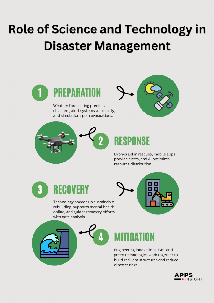
In the ever-evolving landscape of disaster management, the role of science and technology cannot be overstated. Through advanced tools and innovative solutions, technology offers a beacon of hope in the darkest of times, significantly enhancing our ability to prepare for and respond to natural calamities.
From pinpointing the epicenter of earthquakes to real-time monitoring of hurricanes, technology ensures that emergency services can coordinate their efforts more effectively, and residents have the crucial information they need to stay safe.
Beyond the basics of food, water, and shelter, technology like aerial robotics and social media solutions are revolutionizing the way we assess damage, gather data, and deliver aid. For instance, aerial robots can survey disaster-struck areas with unmatched speed and precision, while initiatives like the World Food Program’s Mobile Vulnerability Analysis and Mapping leverage mobile tech to overcome data collection challenges. In sum, the integration of science and technology in disaster management is paving the way towards more resilient communities, proving that with the right tools, we can mitigate the impact of disasters and save more lives.
Do you know? The Importance of Information Technology in Healthcare 2024
Role of Big Data in Disaster Management
Big data enables the early detection of disasters like floods by analyzing various data sources, including remote sensing data and social media. This amalgamation of information helps predict potential flood impacts, durations, and affected areas accurately. For instance, research by Jongman et al. in 2015 showed how combining different data sources could quickly identify the specifics of flood events, enhancing response times and effectiveness.
Big data analysis is like a crystal ball. It can help predict disasters before they strike. When we study data from past catastrophes, we can glimpse the future. We can see what areas and folks might be in danger next. This intel is super important. It helps us plan. We can make responses that hit the target, that really work. Big companies, like Google, are trailblazers in this field. They use spreadsheets and algorithms to foresee floods, especially in places that are used to getting their feet wet, like India. They’re all about making disaster responses on-target and on-time.
By enabling early detection and supporting the creation of predictive policies, technology enhances our ability to respond to disasters more effectively, saving lives and reducing damage. As technology evolves, it promises to bring even more innovative solutions to the forefront of disaster management, making our communities safer and more resilient.
Let’s explore how big data have revolutionized disaster management.
- Efficient Allocation of Resources:
- Big data from geo-informatics and remote sensing platforms identifies where resources are most needed to mitigate disaster risks.
- Helps in recovery efforts, enhances early warning systems, and assesses community resilience, ensuring resources are used effectively.
- Economic Mitigation Plans:
- Big data provides insights into the economic interconnections within communities.
- Analyzes the impact of disasters on various sectors, aiding in the creation of comprehensive economic mitigation plans to minimize cascading effects.
- Social Media’s Role:
- Rapid collection and dissemination of data during crises.
- Allows survivors to mark themselves safe, aiding emergency response teams and providing peace of mind to friends and family.
- Innovative Mobile Applications:
- The American Red Cross offers free mobile apps, giving users access to over 35 custom weather alerts and life-saving information.
- Pilot Projects and Collaborations:
- Google and the Central Water Commission’s collaboration assesses flood situations, showcasing the predictive power of technology in disaster management.
- The Odisha State Disaster Mitigation Authority’s “SATARK” platform provides real-time alerts and warnings for various hazards, exemplifying effective local and national disaster management collaboration.
These advancements are crucial in our ongoing efforts to protect communities and enhance resilience against both natural and man-made disasters.
GIS and Remote Sensing Technologies
Geographic Information Systems (GIS) and remote sensing technologies help grab snapshots from space right after a disaster. Sharing these images online maps the devastation, showing everyone the scale of the damage. The Haiti quake in 2010 saw this practice rise, with folks globally using these pictures to assist. During that quake, the OpenStreetMap group had worldwide volunteers study satellite pictures, checking for ruined buildings and roads. Locals contributed by sharing their observations.
The Digital Elevation Model (DEM), a 3D mapping system, reveals the changes in land height. This can be incredibly useful in understanding floods, such as their depth and reach. The model is created by subtracting water height from land height in an image. But, there is a risk in overly trusting space photos when predicting floods. They can lead to errors like assuming an area is underwater when it isn’t. Even a little error in height measurement can distort flood area estimates. Hence, when using DEMs in water research, potential errors must be kept in mind, particularly during flood mapping.
Must know! How Blockchain Technology is Revolutionizing the Healthcare Industry
Blockchain Technologies in Disaster Management
Think of blockchain as a safe, open, and tamper-proof way to keep and share data across multiple computers. It’s like a digital notebook open for all but owned by none. This notebook records all exchanges or transactions, each one connected to the one before it, creating a chain – hence the name blockchain. But, where does blockchain fit into managing disasters? It’s interesting to see blockchain in this area due to its unique traits. Here are some ways it’s making a change:
Speeding Up Decision-Making
In disaster-prone areas, gathering data quickly and accurately is vital for effective response efforts. Blockchain technology can automate the collection of data, which means that decisions can be made faster, potentially saving more lives and reducing the impact of disasters.
Enhancing Transparency and Trust
One of the challenges in disaster management is ensuring that information is accurate and that resources are distributed fairly. Blockchain’s transparent nature allows for a clear, unalterable record of transactions and decisions. This transparency builds trust between the government and local communities, ensuring that aid reaches those who need it most without being misused or wasted.
Minimizing Misinformation
In the chaos that often follows a disaster, misinformation can spread quickly, making the situation worse. Blockchain technology can help minimize this by providing a single source of truth that is accessible to all stakeholders, including rescue teams, government agencies, and the affected communities.
Optimizing Resource Utilization
Managing resources effectively is critical in disaster management. Blockchain technology ensures that the distribution and utilization of resources are recorded and monitored in real-time, helping to prevent waste and ensure that help is directed where it’s needed most.
Do you know? Importance of Information Technology in Today’s World
GPS in in Disaster Management
Think of the Global Positioning System (GPS) as a superhero in emergency situations. It’s really important. It helps before and during disasters. How? By offering exact, up-to-the-minute details of where everything is. This helps emergency teams assess how bad earthquakes, floods, hurricanes, or wildfires have been. This data is key for planning how to help people leave safely, deciding where resources should go, and setting up rescue missions.
Plus, GPS helps draw out maps of places hit hard by disasters. This helps figure out how much damage was done and how to fix it. It’s also great at helping various groups work together during emergencies, making relief efforts better. By giving precise locations during critical moments, GPS helps cut down on the human and financial toll from disasters, whether they’re caused by nature or people.
Earthquake Warning System
An earthquake warning system uses science and tech to tell us how strong an earthquake might be. It uses tools called seismometers and accelerometers to measure how much the ground is moving. This information is shown on computers to help authorities understand how serious the earthquake could be, so they can start rescue missions better prepared. In studies, like one done by SEER in 2002, scientists use certain methods to guess how big an earthquake could get in a certain area. This helps in planning how to handle it.
Forest Fire Preparedness
Forests are very important for lots of reasons. They give us wood, help store carbon, keep our water clean, and are beautiful places that matter to people’s cultures. They’re also home to many animals and plants. Forests even provide most of the world’s water. They’re worth a lot of money because of all these benefits. But, forest fires can be very dangerous. They can destroy homes, kill animals, and cause a lot of money loss. Fires start slow but can grow very fast and be hard to stop.
Like the big fire in Australia in 2019, it destroyed a huge area and harmed lots of animals. To stop fires before they get too big, technology helps us spot them early. Using tools like remote sensing, satellites, and helicopters, we can see where fires are and how big they are. This helps in planning how to stop the fires, save people and animals, and protect places that are important for the economy. We can also use this technology to figure out how much damage the fire did.
Science and technology are very helpful in managing disasters like earthquakes and forest fires. They give us the information we need to prepare and respond better, which can save lives and reduce damage.
Use of Drone During Disasters
The use of drones during disasters has revolutionized emergency response and management, offering a bird’s-eye view that is invaluable for situational awareness and decision-making. These unmanned aerial vehicles (UAVs) can swiftly navigate through hazardous areas, providing real-time images and data that are critical for assessing the extent of damage, locating survivors, and identifying safe paths for rescue and relief operations.
Drones are equipped with various technologies, including thermal imaging and LiDAR, enabling them to operate in challenging conditions, be it night, smoke, or obstructed environments. Their capacity to deliver essential supplies, such as medicine and food, to inaccessible areas further underscores their role as a pivotal tool in enhancing the effectiveness and efficiency of disaster response efforts, ultimately saving lives and mitigating the impact of catastrophes on affected communities.
Also Read: Top Smart Warehouse Solutions to Boost Your Profits
Weather Radar
Sometimes, bad weather, like too many clouds, can make it hard to take clear pictures from space. This is a big problem when we need to watch for floods. Since the 1990s, experts have found two good ways to keep an eye on floods. One of them uses a special kind of radar called Synthetic Aperture Radar (SAR), and the other uses pictures taken from far above the Earth. The cool thing about SAR is that it can take clear pictures no matter the weather. It works by bouncing radar signals off the ground and measuring them. To see how a flood changes an area, they compare pictures taken before and after the flood, using colors to show different details.
Also, weather radars near the coast can tell us how much it’s raining and how fast the wind is blowing. They can even spot where tornadoes might happen or where the center of a cyclone is. This way, people can get warnings about cyclones hours before they hit.
Final Say
Disasters can lead to terrible losses for people, animals, and things. As we use up more of the Earth’s resources, we’re becoming more at risk of natural disasters. It’s really important to study these disasters using new technologies and to take steps ahead of time to reduce their impact. Technology can help a lot in this effort by making it easier to predict disasters before they happen.
By combining satellite imagery, maps, and the internet, we can detect early signs of natural disasters. Sharing this important information quickly over the internet means we can predict disasters in real-time, helping to lessen their effects.
The way we deal with disasters is changing fast, and technology is a big part of that change. From GPS to different ways of communicating, we’re getting better at responding to disasters. Leaders everywhere need to understand how important it is to reduce the damage from disasters and how technology can help make that happen.
In the 21st century, one of our biggest challenges is to use science and technology to prevent and reduce the damage caused by disasters. While we can’t stop an earthquake or a hurricane from happening, we can make our buildings and systems stronger and give early warnings to save lives and protect property.
Related FAQs
How do remote sensing and Geographic Information Systems (GIS) contribute to disaster management?
Remote sensing and GIS are essential for mapping and analyzing disaster risks and impacts. Remote sensing allows for the collection of data from satellites or aircraft about the Earth’s surface, helping to monitor changes, predict disasters, and assess damage. GIS integrates these data to visualize and analyze geographical information, enabling planners and responders to make informed decisions about evacuation plans, resource allocation, and long-term recovery strategies.
Can technology predict all types of natural disasters?
While technology has significantly advanced in predicting certain types of natural disasters, such as hurricanes, tornadoes, and volcanic eruptions, with reasonable accuracy, predicting others, like earthquakes and tsunamis, remains challenging. Continuous research and development are aimed at improving the predictability of all types of natural disasters, but limitations still exist due to the complex and often unpredictable nature of these events.
What is the importance of early warning systems in disaster management?
Early warning systems are vital in disaster management as they provide advance notice of potential disasters, allowing for timely evacuation and preparation measures that can save lives and reduce property damage. These systems rely on technology and science to monitor environmental conditions and alert authorities and the public about imminent threats, such as extreme weather events or seismic activity, giving people the critical time needed to take action.
How does communication technology aid in disaster response and recovery?
Communication technology is key to effective disaster response and recovery efforts. It enables rapid sharing of information between disaster response teams, government agencies, and the public, facilitating coordination and resource deployment. In the aftermath of a disaster, communication networks support the delivery of aid, reunification of families, and dissemination of information regarding relief efforts, public health advisories, and rebuilding initiatives. Improving and maintaining resilient communication infrastructure is therefore a priority in disaster management strategies.
How can science play a role in disaster risk reduction?
Science helps in disaster risk reduction by studying the causes and effects of natural disasters, leading to better prediction, preparation, and building stronger defenses. This includes creating accurate models to forecast disasters, designing resilient infrastructure, and educating communities on how to protect themselves. By applying scientific knowledge, we can lessen the damage and save lives when disasters strike.